

-
Recently Browsing 0 members
- No registered users viewing this page.
-
Latest Activity
-

By northernsoul · Posted
Lots of negativity on here. Festival veteran from Glastonbury, Life Is Beautiful in Vegas, T in the Park and many others. Loved Sziget last year seeing Amyl and the Sniffers and Sleaford Mods. Looking forward to Four Tet, Kylie and Fontaine's DC this year. Were in a group of aging over 40 plus and it's all about having a carry on with your pals. Music makes it better. -
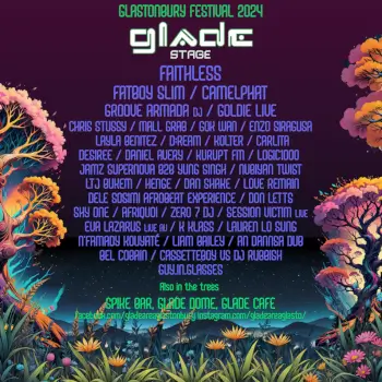
 It’s there if you look for it, bands on hell stage or whatever it’s called this year etc. saw dutty moonshine big band there late…
 -

By Comfy Bean · Posted
Klopp’s dropped more running for a bus than the budget Ferguson had at Aberdeen where he won 2 European trophies. For the record, I was cheering for McLeans Dundee Utd when Fergie was winning cups and titles up here. -
By Yoghurt on a Stick · Posted
Do you mean that they'd never get sufficient funding just from selling small tin boats? I've just recalled that I had previously wondered if the stall owners were also the mill's owners? -
This is right. I’ll be honest it seemed like a madness.
-
-
Latest Festival News
-
Featured Products
-
Hot Topics
-
-
Latest Tourdates


Recommended Posts
Join the conversation
You can post now and register later. If you have an account, sign in now to post with your account.