

-
Recently Browsing 0 members
- No registered users viewing this page.
-
Latest Activity
-

-
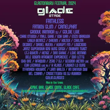
 Some bands that are on Kalorama and were already on BBK, would possibly not be on Mijas, like Massive Attack, Jungle, Overmono... So, i think Kalorama is Safe. Maybe they put LCD or The Smile in Madrid or other Spanish city.
 -

By BillieBobs · Posted
I have no competition updates other than I’m drunk and hoping for an Efest win….love you guys!!! -
By readingnotleeds · Posted
I've been obsessed with the Unpeople ep the last few days, missed them last year but can't wait to see them now. Potential to get huge if this ep is anything to go by -
There's been a second Tony's winner, 3 more to go! Stay delusional guys, keeping everything crossed for everyone. also as a side note, I'm originally from Sittingbourne, not quite Medway but it's funny how there's so many of us from round this way. Good music & festival taste around here!
-
-
Latest Festival News
-
Featured Products
-
Hot Topics
-
-
Latest Tourdates


Recommended Posts
Join the conversation
You can post now and register later. If you have an account, sign in now to post with your account.