
-
Recently Browsing 0 members
- No registered users viewing this page.
-
Latest Activity
-

By Babylon sister · Posted
its been a wet night here so this one seems right this morning 😃 -
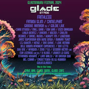
 New stage called the tree stage as well by the looks.
 -

-

By danbailey80 · Posted
I would definitely give it a go. It’s just a few people who hang outside. By all accounts inside it’s great. Also bear in mind that even somewhere like this is still better than anywhere else in the uk on a weekend night out. It’s Glastonbury still. Our descriptions are exaggerated and more as an outsider walking past. I’ve heard loads of tales of great moments from various DJs here. Something else to consider is nearly all the DJs playing here aren’t booked just to play here. They will be playing elsewhere at the festival and usually this is a second extra set they play. E.g Job Jobse will play here 3am Monday morning but he also played at least 2 other places across the weekend. -
By northernsoul · Posted
Lots of negativity on here. Festival veteran from Glastonbury, Life Is Beautiful in Vegas, T in the Park and many others. Loved Sziget last year seeing Amyl and the Sniffers and Sleaford Mods. Looking forward to Four Tet, Kylie and Fontaine's DC this year. Were in a group of aging over 40 plus and it's all about having a carry on with your pals. Music makes it better.
-
-
Latest Festival News
-
Featured Products
-
Hot Topics
-
-
Latest Tourdates


Recommended Posts
Join the conversation
You can post now and register later. If you have an account, sign in now to post with your account.