


-
Recently Browsing 0 members
- No registered users viewing this page.
-
Latest Activity
-
 Alkaline Trio 90 Barrington Levy 95 Basement Jaxx 120 Billy Bragg 100 Billy Ocean 100 The Black Keys 90 Carl Cox 100 Chase & Status 115 Chelsea Wolfe 80 CMAT 105 Confidence Man 150 MAX Dave 25 David Byrne 150 Disclosure 65 Everything Everything 105 Faithless 80 Fatboy Slim 100 Four Tet 125 Funeral for a Friend 45 Garbage 100 GOAT 105 Greentea Peng 120 Happy Mondays 80 Hollie Cook 90 Jorja Smith 100 José González 100 Joy Crookes 120 Judas Priest 90 Kasabian 80 Kneecap 110 The Last Dinner Party 15 Levellers 85 Limp Bizkit 35 Linkin Park 90 Lorde 120 Madness 75 The Maccabees 100 Neck Deep 135 Nile Rodgers & Chic 100 Overmono 100 Pixies 55 The Prodigy 140 Pulp 150 MAX RAYE 100 Ren 85 Richard Ashcroft 95 Say She She 85 Scissor Sisters 120 Self Esteem 120 Skunk Anansie 100 Stereolab 120 The Streets 110 Super Furry Animals 110 Tems 50 Thundercat 90 Tom Jones 70 Two Door Cinema Club 20 Tyler, the Creator 75 Underworld 115 Wet Leg 90 Wilco 85 (-10) The Wombats 90 Wolf Alice 135
 -

By northernangel · Posted
Not necessarily but it should be, Download have a habit of messing it uo when others get the bookings on point. Good Charlotte I doubt are playing 3rd down and that too 3 that day while dreamy is too strong. I think you'd have one another day to help sell weekend tickets. I also doubt Papa Roach play. -
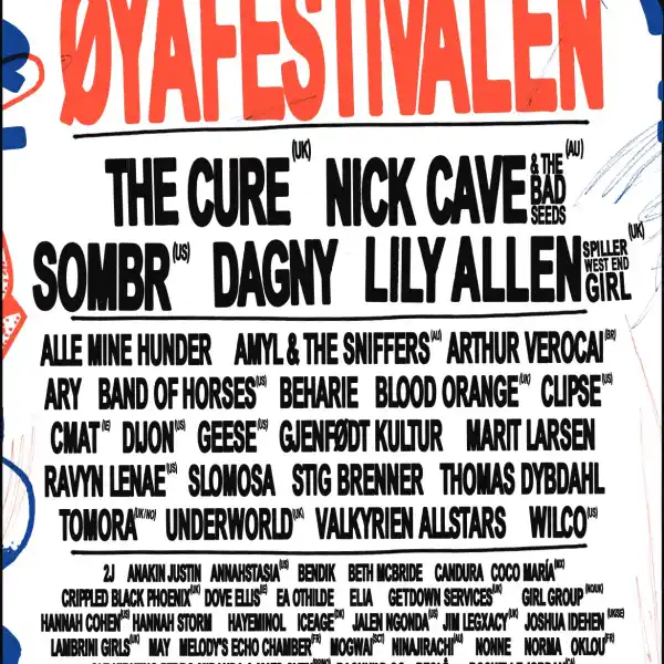
 Here's a bit of a wild stab, few placings may be off, and for all I know half of these won't actually be touring next year, but screw it, it's a bit of fun Pyramid: Sabrina Carpenter, Phoebe Bridgers, TBA (Florence + The Machine), Garbage, The Last Dinner Party, Interpol, Alex James Britpop Classical Other: Chase & Status, Teddy Swims, Clairo, The Kooks, Zara Larsson, Kingfishr, Sports Team, Orbital West Holts: Robyn, Baby Keem, De La Soul, Deltron 3030, JID, Dua Saleh, kwn, Daniela Latila Woodsies: Bonobo, Darkside, TBA (Tame Impala), Laufey, Warmduscher, Wednesday, The Lottery Winners, The Royston Club, Florence Road Park: Patti Smith, Super Furry Animals, Slayyyter, The Cardigans, Skye Newman, Kelly Lee Owens, Teen Jesus & The Jean Teasers Pyramid: Harry Styles, The xx, Richard Ashcroft, The Pogues, Jessie J, Sigrid, Travis Other: Rosalia, Sombr, Mitski, Alex Warren, Holly Humberstone, Cat Burns, Pale Waves, Yard Act West Holts: Basement Jaxx, Elyanna, Clipse, L’Imperatrice, Nation of Language, Jim Legxacy, Yazmin Lacey, RIP Magic Woodsies: Suede, Chvrches, Bleachers, MUNA, The Cribs, Keo, Bleech 9:3, The Lilacs Park: MARINA, Magdalena Bay, Jacob Alon, TBA (Lily Allen performs West End Girl), Getdown Services, Isaac Wood, Snail Mail, Madra Salach Pyramid: Sam Fender, Hozier, David Byrne, Cher, Obongjayar, David Gray, Billy Ocean Other: Doja Cat, Deftones, Addison Rae, Ren, Viagra Boys, Maisie Peters, The Reytons, Hard Life West Holts: Kano, Thievery Corporation, Angine De Poitrine, Thee Sacred Souls, Brooke Combe, Sasha Keable, Master Peace Woodsies: The Wombats, Metronomy, Geese*, Dry Cleaning, EsDeeKid, Sienna Spiro, Cowboy Hunters, Radio Free Alice Park: Big Thief, Laura Marling, MJ Lenderman, Richard Dawson, Oklou, Maruja, Dead Dads Club, Ratboys *There's always one band booked for Woodsies that ends up being massively under-billed and gets shut down really early. They'd be better off playing somewhere like Other sub, but I could see the G getting them to play a smaller stage while it's still possible
 -
.thumb.jpg.e25824f1386da28e145b5b6d336f152d.jpg) Another Kraftwerk one for me today, as just back from seeing them.
Another Kraftwerk one for me today, as just back from seeing them. -
 Completed my 2026 survey. Put down Super Furry Animals as my most wanted for next year but suspect the moment has gone for that. Popped a big shopping list in the box for who else you would like to see. 🙂
-
-
Latest Festival News
-
Featured Products
-
Hot Topics
-
-
Latest Tourdates


Recommended Posts
Join the conversation
You can post now and register later. If you have an account, sign in now to post with your account.