


-
Recently Browsing 0 members
- No registered users viewing this page.
-
Latest Activity
-
 In August 2009, in his Spectator blog he wrote about Harriet Harman, deputy leader of the Labour Party, in unflattering terms. Liddle began the article by asking: "So — Harriet Harman, then. Would you? I mean after a few beers obviously, not while you were sober."[27] Tanya Gold wrote in The Guardian that Liddle had delivered a "tissue-thin polemic." Pointing out that it was The Spectator's cover story that week.[28] Rachel Cooke in The Observer nearly two months later recalled finding Liddle's piece "disgusting"[29] Cooke went on to say: "I would still like to do something really unpleasant to the man who wrote [the article]." Liddle said two months later that the Harman column "was supposed to be a parody of guttural, base sexism", a joke he assumed readers would understand. After the negative response from Gold (and then Cooke, among other female journalists) he continued: "And then I suppose I came to the conclusion – gradually – that I must have got it wrong."[30] In June 2014, he said that of those he had offended, Harman was the one person to whom he would apologise.[31] In November 2009, again for The Spectator website, he offered "a quick update on what the Muslim savages are up to," a brief article about the stoning to death of a 20-year-old woman in Somalia after she was accused of adultery, and the similar death of a 13-year-old the year before. He made remarks, considered sarcastic, that read: "Incidentally, many Somalis have come to Britain as immigrants recently, where they are widely admired for their strong work ethic, respect for the law and keen, piercing, intelligence."[32][33] In December 2009, on his Spectator blog, Liddle referred to two black music producers, Brandon Jolie and Kingsley Ogundele, who had plotted to kill Jolie's 15-year-old pregnant girlfriend, as "human filth" and said the incident was not an anomaly. He continued: When he was accused of racism, Liddle said he was instead engaging in a debate about multiculturalism.[35][36] In March 2010 the Press Complaints Commission (PCC) upheld a complaint against Liddle, who became the first journalist to be censured over the contents of a blog, because he had not been able to prove his claim about the crime statistics.[37] After the publication of London crime figures in June 2010, The Sunday Telegraph suggested Liddle was largely right on some of his claims, but that he was probably wrong on his claims about knife crimes and violent sex crimes.[38] In October 2010, Liddle called for the abolition of the Welsh language TV channel S4C as a result of the 2010 Comprehensive Spending Review. In his article for The Spectator, he described Welsh nationalists as "miserable, seaweed munching, sheep-bothering pinch-faced hill-tribes".[39] On 23 May 2013, Liddle wrote about the murder of soldier Lee Rigby near the Royal Artillery Barracks in Woolwich, London. In the original version of a blog article for The Spectator, he referred to the perpetrators as "two black savages".[40] After many objections to his language use,[41] this phrase was modified.[42] Liddle apologised.[40][43] Giving a speech at Durham University in December 2021, Liddle said: "It is fairly easily proven that colonialism is not remotely the major cause of Africa's problems, just as it is very easy to prove that the educational underachievement of British people of Caribbean descent or African Americans is nothing to do with institutional or structural racism."[44] Independent editor rumour and Millwall supporters' website The Guardian reported on 8 January 2010 that the expected purchase of The Independent by Alexander Lebedev, a Russian billionaire, would be followed by the appointment of Liddle as editor.[45] Roy Greenslade wrote on 11 January that the reports were provoking a "major internal and external revolt" by The Independent's staff and readers.[46] The stories about Liddle's posts on Millwall Online apparently further reduced the likelihood of his being offered the job.[47] Finally, on 19 February, Stephen Brook of The Guardian reported that Liddle was no longer in the running for the post.[48] Tim Luckhurst, professor of journalism at the University of Kent, argued that Liddle's prospects of editing The Independent were nullified "by the people behind a viciously intolerant campaign of liberal bigotry".[49] In January 2010, the press drew attention to allegedly racist and misogynist comments posted under the username "monkeymfc"—a name Liddle has used—on Millwall Online, a fan club web forum with no official connection to Millwall Football Club. Liddle attributed some of the comments to opposition fans logging in under his name to embarrass him. He later said he had written some of the posts that were being criticised, including one in support of the BNP excluding Black and Asian people from the party.[50] Another post, in which he joked about not being able to smoke at Auschwitz,[51] led to his being asked to explain what he meant in The Jewish Chronicle.[47] While he said in June 2014 that his comments were taken out of context, he said that he did not regret making them. "No. Never. Absolutely not. I thought about my mates at Millwall Online, God I respect them so much more than these other people, these ghastly f**king people."[31] Stephen Lawrence, disabled and transgender people In November 2011, an article by Liddle for The Spectator suggested the trial of two men accused (and later convicted) of murdering Stephen Lawrence would not be fair.[52] It was referred to the Attorney General Dominic Grieve by the judge for possible contempt of court,[53] and he ordered the jurors not to read it. Having decided that it might have breached a court order, Grieve passed the case on to the Crown Prosecution Service and the Director of Public Prosecutions.[54] The decision that The Spectator was to be prosecuted by the CPS for breaching reporting restrictions was announced on 9 May 2012, with a court hearing scheduled for 7 June, although Liddle as the author was not himself liable for prosecution. Fraser Nelson, the magazine's editor, announced that the prosecution would not be contested,[55] and the magazine pleaded guilty at the hearing. The fine was £3,000, plus £2,000 compensation to Stephen Lawrence's parents and £625 costs.[56] In January 2012, Liddle wrote that many people in the UK were "pretending to be disabled" in his column for The Sun,[57] an opinion defended by James Delingpole.[58] Frances Ryan in The Guardian accused him of "belittling something that on a daily basis affects real people" who can be "a huge benefit to society. Maybe for a month Liddle would like to try that."[59] In May 2015, the Independent Press Standards Organisation (IPSO) upheld a complaint from Trans Media Watch that Liddle had been discriminatory towards Emily Brothers, a blind and transgender Labour candidate at the 2015 general election, in two Sun columns published in December 2014 and January 2015. In commenting in the way he had Liddle had breached two sections of the editors' code.[60][61] Column on poppers and gay sex During a parliamentary debate on the Psychoactive Substances Bill – which "makes it an offence to produce, supply, offer to supply, possess with intent to supply, possess on custodial premises, import or export psychoactive substances"[65] the Conservative politician Crispin Blunt admitted he used poppers: Liddle responded in his Spectator blog: The satirical and current affairs magazine Private Eye described this as hypocritical, pointing out Liddle's account in The Sunday Times of using Viagra in July 2004.[68][69] A spokesperson from the LGBT rights charity Stonewall said of Liddle's remarks: "Comments like this are shocking and damaging, but we wouldn't expect anything less from repeat offending bigots like Rod Liddle."[70] Column on Muslim voters In October 2019, Liddle penned a column in The Spectator commenting on the forthcoming December 2019 UK general election, which suggested that the election should be held on a Muslim holy day to reduce the Labour vote. The column was criticised by senior political figures including Chancellor of the Exchequer Sajid Javid and former Conservative Deputy Prime Minister David Lidington. Liddle defended the content as being humorous. The article also criticised the Labour MP Rosie Duffield's recent speech about her experience of trying to exit an abusive relationship; Duffield described the article as "racist and misogynistic".[74]
 -
-
-
 I thought the same thing I thought when Baresi went which is there sure is a hell of alot of people who don't make the new pension age.
 -
 1, The Menzingers- Everything I Ever Saw 2, Quicksand- Bring On The Psychics 3, Radkey- Bedroom Sand
-
-
Latest Festival News
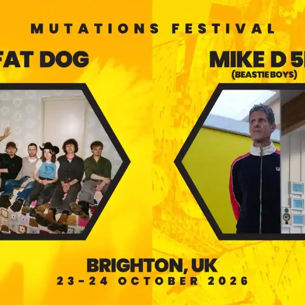 Brighton Mutations Festival 2026 announces Fat Dog & Mike D 5D (Beastie Boys) as first headliners
 Early Bird Tickets For IOW 2027 Now On Sale
 Radio 2 in the Park announces line-up as tickets go on sale
 Glastonbury Alternatives: 20+ Festivals for Summer 2026
 Simple Things announce first wave of line-up
 -
Featured Products
-
Hot Topics
-
-
Latest Tourdates


Recommended Posts