

-
Recently Browsing 0 members
- No registered users viewing this page.
-
Latest Activity
-

-
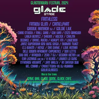
 Ah yes, but anyone that cancels between now and next week will be cancelling because they’ve got a ticket in the resale or their situation has changed, not because they don’t rate the line up this year!
 -

-
Worth noting that with Festaff, doing Glastonbury is conditional on you signing up for a second festival too!
-

-
-
Latest Festival News
-
Featured Products
-
Hot Topics
-
-
Latest Tourdates


Recommended Posts