


-
Recently Browsing 0 members
- No registered users viewing this page.
-
Latest Activity
-
 Crikey. I remember Muse cancelling a Lolla headline set in 2017 due to a massive thunderstorm after only 3 songs. Clearly this is an area of the world where the storms don't f**k around.
 -

By DomDom1984 · Posted
I still think they might take another shot at the normal weekend. I'm also pretty sure this exact same speculation was happening after the last one. -
 Meanwhile in Chicago. Rained overnight at Lolla. Now they pushed back opening til the afternoon. But thunderstorms and lightning forecast. Maybe if the city invested in proper drainage they couldve tried to salvage the day.
 -
 Wasn't just me who thought it was either oversold or inadequately setup for the event then? For Pride, over the weekend, where there's also acts in the large blue marquee that was to the right of the "arena" (for want of a better term), it's probably much better as people are dispersed more. Thought the band were great, as was Nick, though he was clearly struggling with his voice at times.
 -
 I got in for £11.25 in the end, which was absolutely ridiculously good value, and made the queues and overselling of the venue much more tolerable! Sniping in on other people’s unwanted tickets on the day of an event might become my new hobby I think 🥳
-
-
Latest Festival News
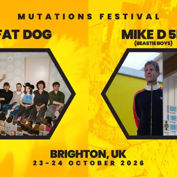 Brighton Mutations Festival 2026 announces Fat Dog & Mike D 5D (Beastie Boys) as first headliners
 Early Bird Tickets For IOW 2027 Now On Sale
 Radio 2 in the Park announces line-up as tickets go on sale
 Glastonbury Alternatives: 20+ Festivals for Summer 2026
 Simple Things announce first wave of line-up
 -
Featured Products
-
Hot Topics
-
-
Latest Tourdates


Recommended Posts