

deadstillstanding
-
Posts
81 -
Joined
-
Last visited
-
Days Won
5
Content Type
Profiles
Forums
Blogs
Gallery
Store
Posts posted by deadstillstanding
-
-
About 6pm this Friday. I'm crewing on the Green Welfare tent again this year and can't wait to get onsite already...
-
That's the hope. They've asked non-essential staff to delay coming until tomorrow (extended their car passes etc) if they can just to limit traffic.
-
30 minutes ago, paulo999 said:
The massively flooded bits have emptied out. It was the whitelake river that burst, in the same place it did in 2005.
There's still standing water in a couple of places, and the fields are generally squelchy, but there's still time for recovery.
Here's hoping
")
Right. It's pretty wet underfoot everywhere and where it's been churned it's messy. Met a bunch of crew from different teams who lost time yesterday. Although overcast it doesn't look like rain today. Most are gonna make the most of it and do a big day.
-
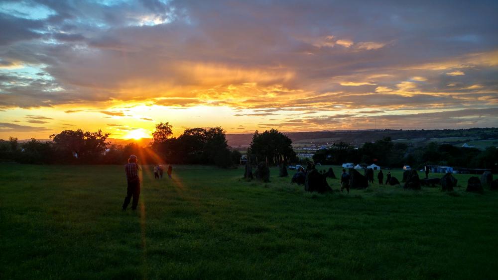
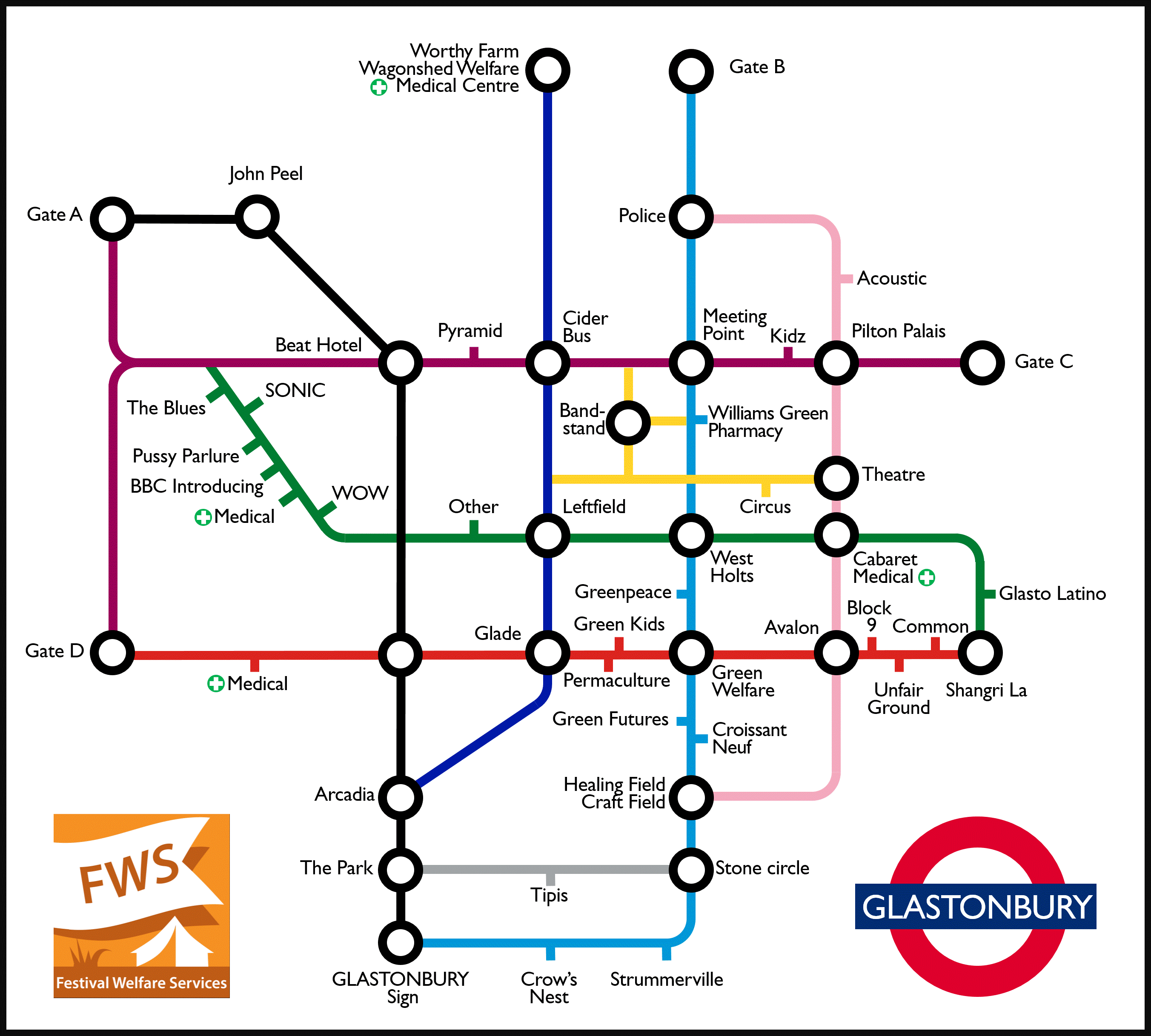
And here's the finished sign and last night's sunset from the stone circle

Thanks everyone that helped and I hope you all have a great festival!
-
2 hours ago, russycarps said:
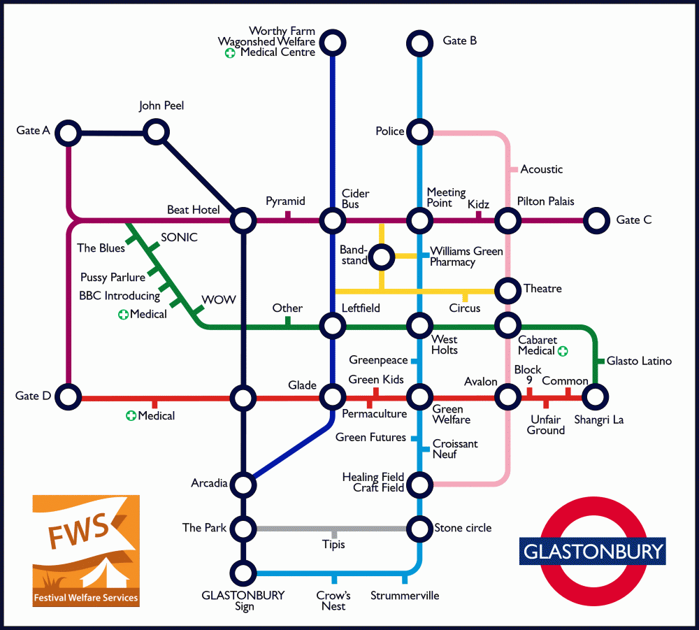
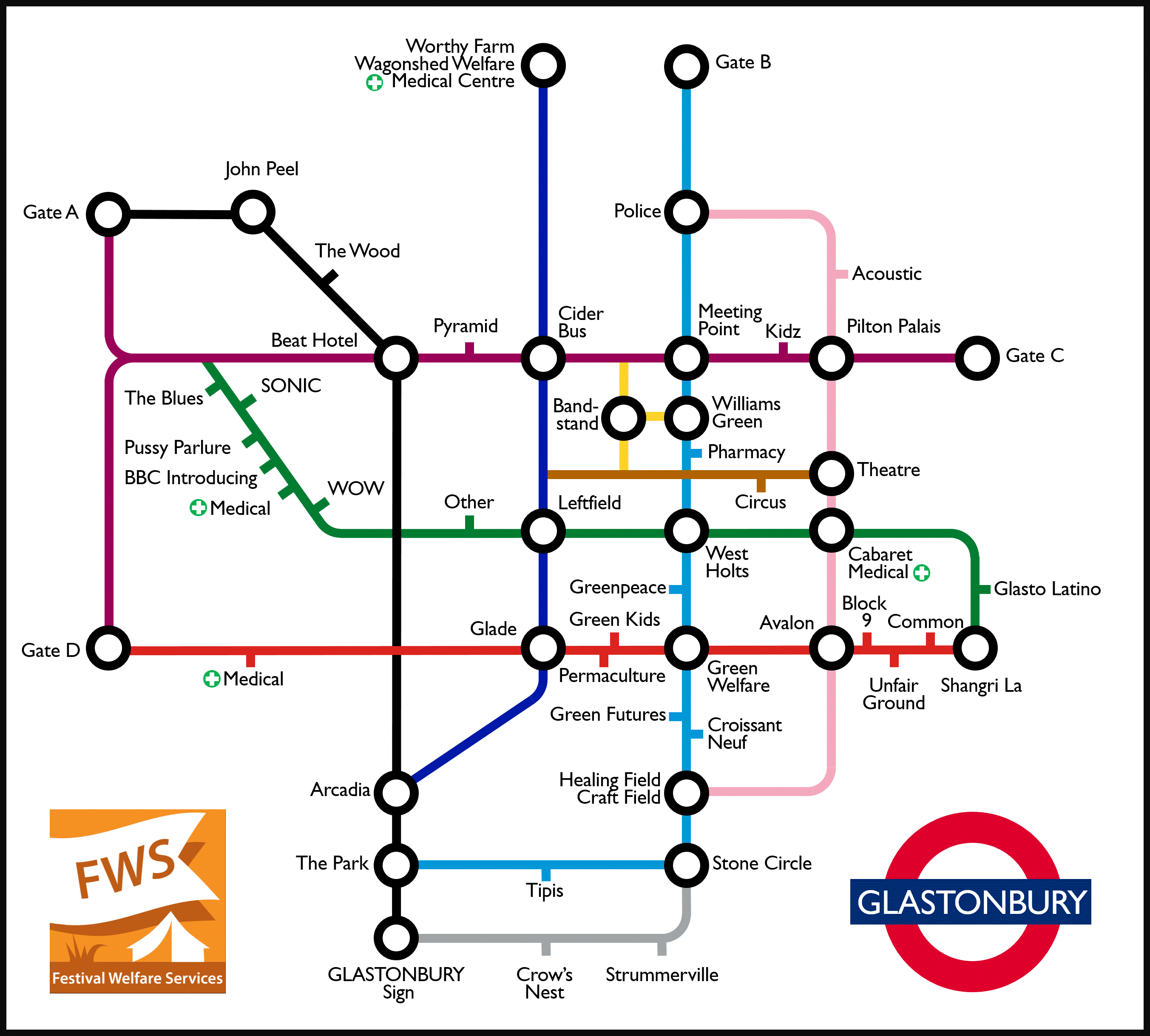
The junction in between medical and the glade needs naming. It's bugging me. Cant really call it hill of death anymore after they flattened the deadly slope a bit a few years back.
Dammit. Missed that one. Good point.
1 hour ago, al_coholic said:Guess Oxlyers or Glade Lounge would be most suitable names
Glade Lounge is over the other side. Hill of Death isn't a bad idea but I'm trying to stick with landmarks like stages or important facilities – stuff that a lost punter can figure out and orient themselves by. But Oxlyers is only useful if you already know that's what that field is called... Besides, I haven't named any other camping fields.
Basically I need to just delete that station, which I'd totally forgotten to do. Have deleted it now from the png.
Thanks both!
-
1 minute ago, siblin said:
You could have equivalents to the national rail links at the gates to the coloured car parks and campervan fields. Strummerville should connect to pennard hill gate and worthy view
The National Rail links for gates suggestion is a nice idea but (barring any major mistakes) I've locked this down now. Have already burnt too much time on it. Besides, I'll sperge out, take it to the n'th and start putting M4, M5 and A303 signs next to the respective gates and... it never stops!
None of the camping fields make the cut – it's just too much information – and Pennard Hill Gate falls under that logic.
-
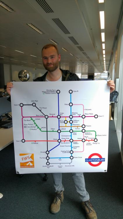
Right. Added The Wood. Made the walk up and along the ridge into the Jubilee. I think this is it!
If anyone wants to go crazy making mugs and T-shirts at Cafepress or wherever that's cool – here's the png. Donations to Festival Welfare Services are totally welcome! Or come by, say Hi (I'm the big guy called Pete), and drop some cash in the bucket outside Green Welfare (between Crossiant Neuf and the railway track).
Take care of each other and have a great festival!
-
Predictably I've had a change of heart. More curviness was needed, the Leftfield/Other/Glade bit was going my nut and the junction stations were ugly. This could be the final right here I reckon. Gonna sit on it overnight tho'. Enough updates for one day already!
-
Thanks all for the kind words! I'll be very glad if it's genuinely helpful.
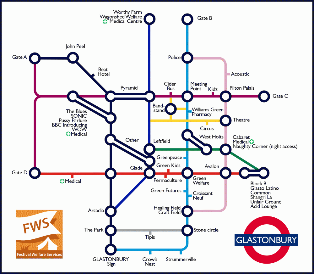
Okay... Loads of updates made here inc. those mentioned earlier in this thread. Made the whole market/bandstand bit more detailed but hopefully more useful also. Got Green Kids and the Pharmacy on. Fiddled a few routes to be more realistic. Stuck in a few curves to make it easier on the eye. It is getting nuts busy – defying the point a little – and the whole Glade/Leftield/Other thing is a bit ugly (but accurate)... but I think I'm broadly happy with this... Any final thoughts?
-
48 minutes ago, Bathimp said:
apart from perhaps the Gate D to Sonic connection. Well done!
Right you are. Will add that.
28 minutes ago, incident said:I'd stop the Grey line at the Acoustic - for me, the Police compound and PGB more naturally fit north of Williams Green as a continuation of the Main Drag when it turns into Muddy Lane. Or maybe do that and have the Grey line turn left to join up with the Blue line at a new junction "Cockmill Family Camping"
Yeah, good shout. Thanks.
I'm pretty sure I remember walking from the top of Kings Meadow across behind/uphill of the tipis to the top of the Park... but then I don't trust my memory very much so... will check that one tomorrow!
-
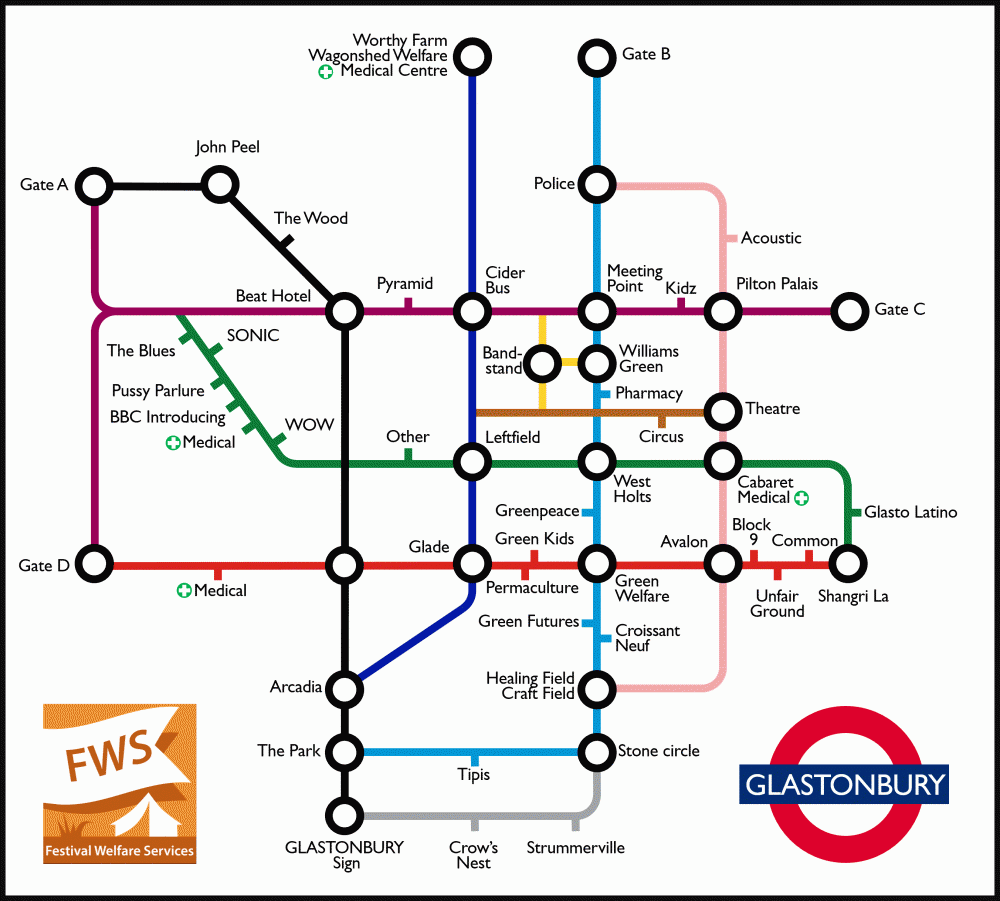
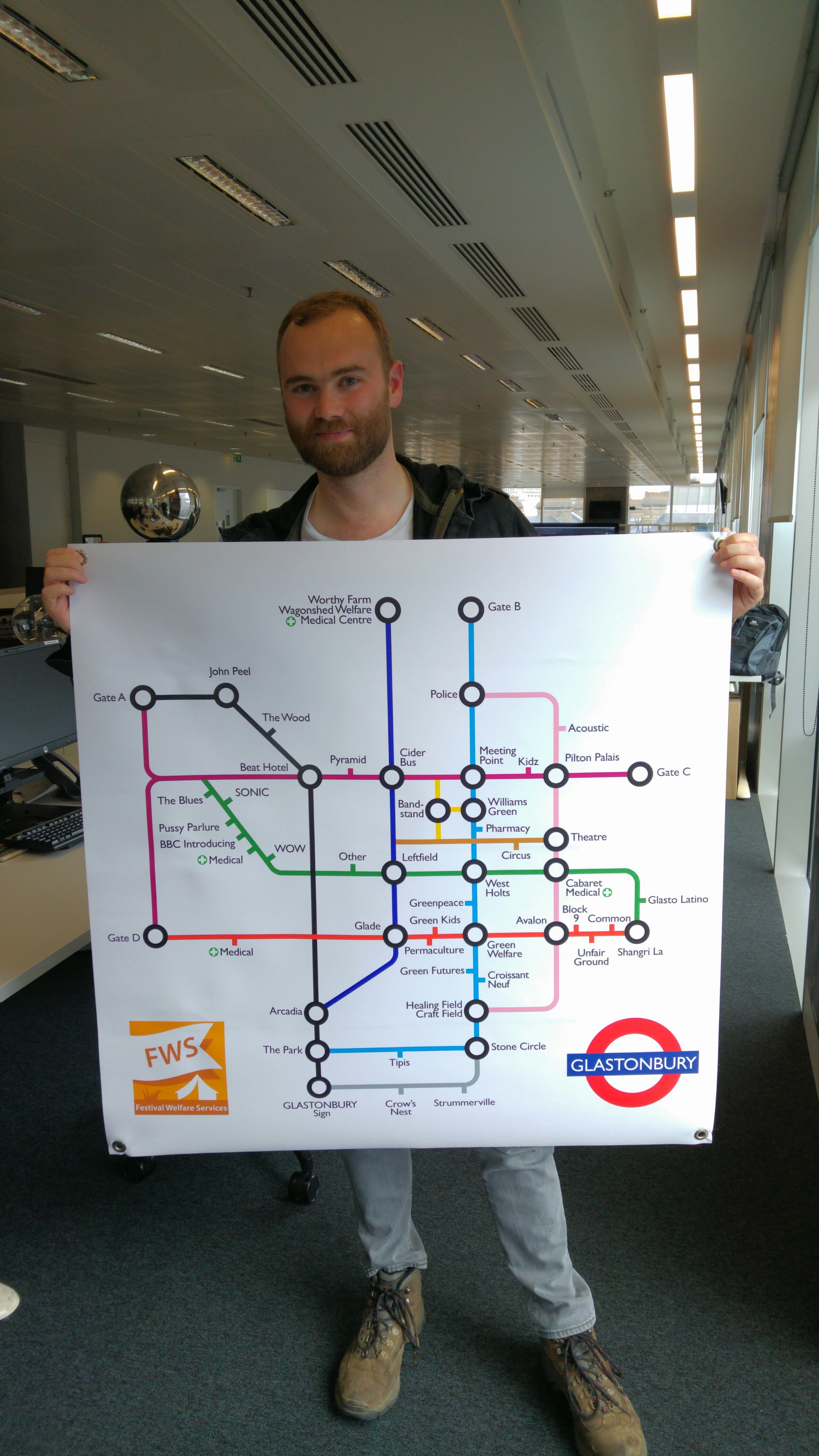
Hey everyone, long time no post. So long my avatar and post count have crashed out! Hope you're all doing good.
I volunteer on the Green Welfare tent (next to the railway and Croissant Neuf) these days. As well as providing anonymous support to anyone that needs it (lost kids, lost souls, anyone that's losing it a bit) we end up giving directions a lot. I've tried making a simple map of the major walking routes and stages based on the style of the classic Tube map. We might make a poster for the tent or something. I've had to make a bunch of compromises to make it work which will be instantly obvious to veterans - some access points aren't shown, naming shortcuts, distances and angles have been normalised - but I hope it still helpfully lays most stuff out.
So I wanted to see what you all reckon? Anything unhelpful I could fix before I print it? Bear in mind I can't add much - it's already pretty packed. Looking forward to your thoughts.
-
I arrived early afternoon on the Monday last year and walked right onto one. Left within 10min with me and a handful of others. Cannot wait...
-
Great pics! Glade looks great, lovely to see that back. Permacultures had a bit of a facelift which is grand toodidn't recognise the blue and yellow topped thing, this disturbs me
-
Brilliant photos thanks a lot!
I think the silver heyes thing you're referring to is the blues stage
-
Really hot sunny day onsite today
 Still nicely warm now. I took a few photos walking from Pedestrian gate A to Greenfields if you're interested. You can see Arcadia's new home, there's some kind of favella-type installation in Silver Hayes and great to see the Glade coming back.
https://plus.google.com/photos/108603235247686418270/albums/6028196488941232289
-
Bah.¨Holding page now says
Glastonbury Festival 2014 Ticket deposits have now sold out.Resales in the new year then

-
Man, that sucks
Suggest you phone your embassy first thing in the morning and find out how long an emergency passport takes. As it stands you won't get back to London until late afternoon which can't be enough time to sort this out. You might need to return on Sunday afternoon so you can rock up at the embassy 9am Monday or even go today before you head into the festival. -
Nope, coach tickets are still available.
-
Nice one Halvin – your Clashfinder is always great dude, really appreciate the effort

<ch-ching>
-
Love it
 Genius!
 -
Let's see what they've got to say http://www.netweather.tv/forum/index.php?showtopic=38035


2017 Glastonbury tube map
in Chat
Posted · Edited by deadstillstanding
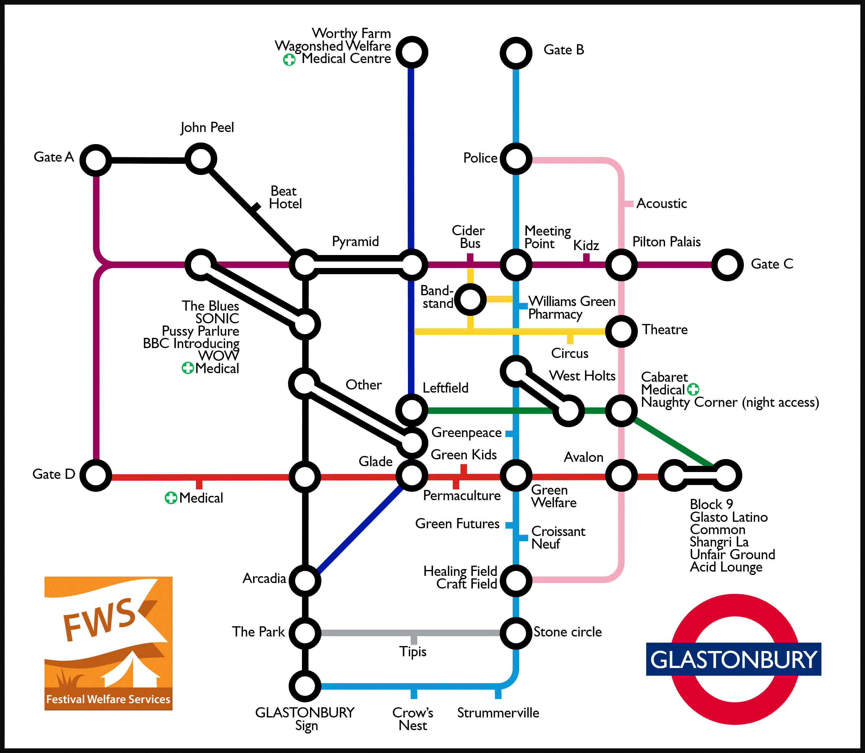
Hey everyone!
I made a tube map of the site last year that some people seemed to find pretty useful. Well I've updated it for 2017 – basically just by adding Cineramageddon. Hope it helps!
I'll be onsite on Friday and wish you all an excellent festival. If you or anyone you meet runs into any difficulty of any kind, please come and check in with us at welfare – we can help, in confidence, no questions asked. I'm in the Green Welfare tent by the old railway track (the one with this map stuck to the outside...).
- Pete
PS Last year a few people requested a high res image with a transparent background for high quality printing, so here's that version too.