

deadstillstanding
-
Posts
81 -
Joined
-
Last visited
-
Days Won
5
Content Type
Profiles
Forums
Blogs
Gallery
Store
Posts posted by deadstillstanding
-
-
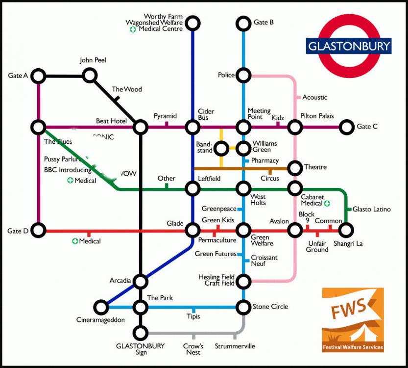
Last call for any detailed layout info for the smaller venues in the south-east corner, Silver Hayes and Park...? I'm gonna finalize the tube map and send it to print tomorrow I reckon. Will go with the level of detail on the public map unless anyone's got a better one yet?
-
On 5/18/2022 at 4:36 AM, blutarsky said:
If all the Park and Silver Hayes stages are on there individually then the SEC should have detail added and include NUC Downlow, Gas Tower, Genosys, IICON etc rather than simply Block 9, Shangri La, Common and Unfairground.
Poetry and Words, Sensation Seekers also not on there.
On 5/19/2022 at 12:10 PM, blutarsky said:Will you be able to add the SEC stages rather than just areas?
On 5/19/2022 at 3:43 PM, deadstillstanding said:I can physically only include so much detail - without dropping to a smaller font and making something too detailed to serve the original purpose of a simple map anyone can use - so a lot of the smaller venues, e.g. in Silver Hayes and the Park get omitted unfortunately. I do try to pack everything in but it's kind of at its limit.
Do you (or anyone?) have a map of this year's SEC?
I've trying a new scaling on the map. I've kept it broadly realistic before but have tried vertically stretching out the crunched up south and middle more at the expense of the north. Kind of a reverse Mercator in favour of the south/Greenfields, which I'm fine with. Gives me a bit more room for SEC but need to refer to a map to place pins. My memories of that area are not... good enough.
-
On 5/19/2022 at 5:05 PM, Beerqueen said:
I think when it was put on here before it was suggested that anyone who had it printed, swung by the welfare tent to make a donation, which I indeed have done. Though I must admit, I had forgotten who it was though I can picture the tent!
Yeah, that's the size of it. Years ago, I did look into the charity that runs the Green Welfare tent (who I volunteer with) selling T-shirts and mugs or whatever to raise funds. Transport for London are fine with people using the style of their map, they just won't let you use the roundel as is. They even suggested doing it with a different background shape, hence the pyramid. But Glastonbury Festivals Limited is reasonably protective of its trademarks, including the stage names (e.g. 'The Pyramid Stage' is ™), so those labels can't be used on something being sold. So we just print a mega sized version on the side of the Green Welfare tent, and I stick it online for people to sort themselves out.
-
 1
1
-
-
3 hours ago, blutarsky said:
Will you be able to add the SEC stages rather than just areas?
I can physically only include so much detail - without dropping to a smaller font and making something too detailed to serve the original purpose of a simple map anyone can use - so a lot of the smaller venues, e.g. in Silver Hayes and the Park get omitted unfortunately. I do try to pack everything in but it's kind of at its limit.
-
 1
1
-
-
On 5/17/2022 at 10:13 PM, gooner1990 said:
Could do with a 2022 version of this. 😁
I was literally gonna start updating it tonight 🙂
As before, will share here/Insta/Twitter once ready, as well as print out a mega sized banner to hang on the side of the Green Welfare tent (where I volunteer) - just off the railway track into Greenfields. There's a rumour we might raffle it off on the Sunday so please swing by to buy a ticket (say Hi to the big guy named Pete 😉). Proceeds will go 50:50 to support the welfare charity and Ukraine.
-
12
-
-
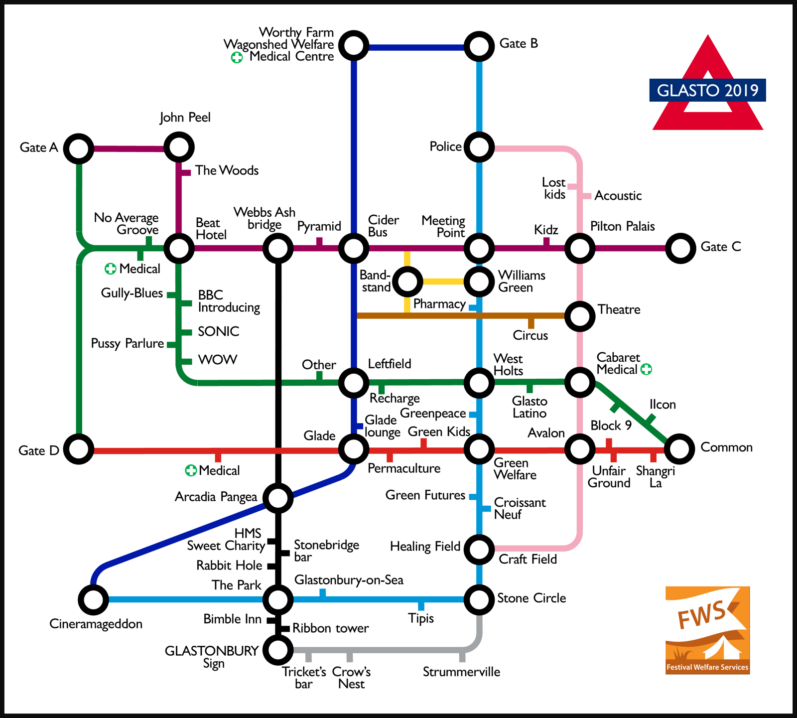
And here we go...
https://drive.google.com/drive/folders/1u_-48BuZvGwSIIF-vBhJ6fdjL1izXjUd?usp=sharing
A massive A0-ish pdf that I'll use to make the poster. An 1800x1603 version that'll do A4 (ahem or a T-shirt) both with a white or transparent background. A 1080x1920 version you could use as a lockscreen. And versions with Spring Ground camping on as a favour for a friend.
Have also made a couple of small fixes here or there.
-
2
-
3
-
-
On 6/4/2019 at 5:14 PM, anditmakesmesmile said:
Though if you a vector version even better. Sorry to be so cheeky and demanding.
If only I had the good sense to draw it in something sensible and not PowerPoint. Yes really. I'm a slide monkey and a sucker for punishment I guess.
I'll be exporting an A0ish print quality pdf at some point to make the poster for the FWS marquee. Will pop a link on here when I do.
-
12 hours ago, deadstillstanding said:
Thanks re. the Pharmacy, that's good to know. So would that be in P28 on the Site Plan I'm guessing?
Confirmed this with GFL. It's next to Bread & Roses at that junction so have put it there.
4 hours ago, anditmakesmesmile said:My eyesight isn’t as good as it used to be. Perhaps you could make a hi-res version available to help me and those with similar eyesight problems. Which we wouldn’t, of course, use to get t-shirts printed. I am sure that we all would, totally unconnected, be happy to drop in a donation to Festival Welfare Services.
For sure. Here's a high res version: https://drive.google.com/open?id=18mTD3L4iyQZ8T8MYWy7grzam04vjgghq That'll print to A4 at 150dpi.
2 hours ago, guypjfreak said:Does that apply to paintings as I'm working on a project to do 12 paintings of glastonbury.. Now obviously you call your painting something ie.. Glastonbury pyramid in the sunset .. Or ribbon tower something or other.. Am I allowed to call my original paintings these names.. Otherwise I'll have to change it to.....
A bright thing in a field.......
Doesn't sound so good does it lol
I'm no expert, you'd really have to check with GFL, but I'd imagine that just naming a piece that way is fine. It's using those trademarks within the piece itself that would be problematic.
2 hours ago, Ross Brown said:Couple of comments - Stone circle is much further to the right than Glade. I can see why you have done this to fit everything in but it would benefit from a line joining these together as there is a main route from Strummervile/Stone Circle to Glade.
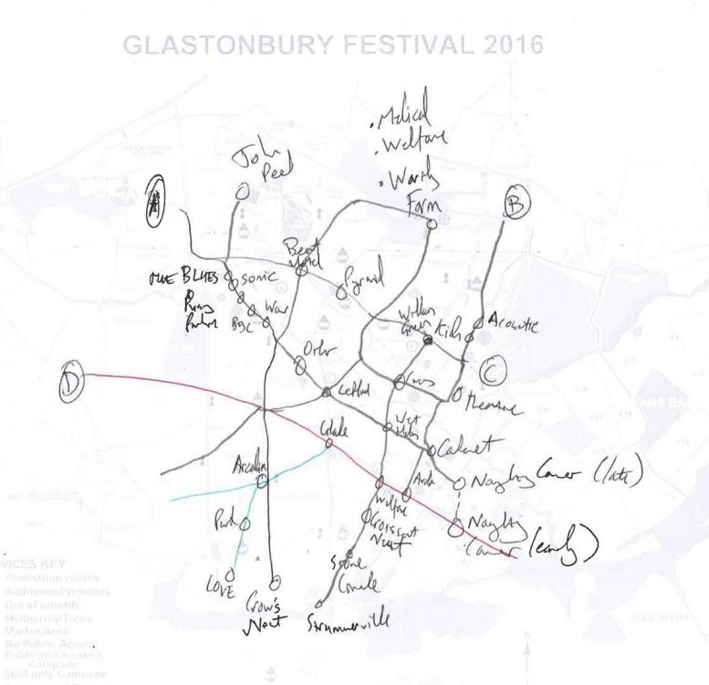
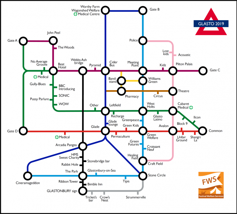
The map doesn't run 'true' north-south, just how I've always felt the site works if that makes sense. In my head the railway track junction down from the stones (where Welfare is as it happens) is the centre of my Glasto compass so to speak – so that's my north-south axis. If you're curious this is how it got started.
Putting that route from the Glade to Kings Meadow makes sense though. Have added.
2 hours ago, ian the worm said:This year Bimble Inn is where Rabbit Hole was.
On your 2019 map this should place the ribbon tower slightly north of Bimble Inn.
Thanks! Have updated.
2 hours ago, Ross Brown said:Also next to Strummerville on the corner it would be good to add Pennard Hill Gate for the Worthy Viewers.
1 hour ago, pmcmanu2 said:Only thing I considered that could be an extra "station" was worthy view - I know its technically outside the site (like CV field etc), but personally I think it has sort of become a "feature" of Glastonbury......
15 minutes ago, Smash1984 said:Only thing I would add is a stop for WV, looks like you could squeeze it on below the bend before strummerville. Good work!!
")
Nah. Thanks for the suggestion but the map doesn't list any of the campsites (well, I guess you could argue the tipis are but I'd argue they're a bit special) so I'm not gonna start with one that's offsite and most people can't even access.
Thanks everyone for the input and the kind words. It's honestly means a lot. I think this is pretty much done now ?
-
1
-
-
Whoops. Double posted somehow.
-
1 hour ago, keepad said:
Great work, it would be great to get this printed up as a T-shirt, well done ?
1 hour ago, Vegansausageroll said:Talented, good work ?
Edit: I’d buy a mug print
1 hour ago, dccool said:I'd buy a tea towel with that printed on it. Excellent work ?
4 minutes ago, guypjfreak said:Get a few printed off.. A3... They would sell
Thank you. After a bunch of people were kind enough to say the same the last couple of years we did look into it with the idea that proceedings would go to Festival Welfare Services but no dice sadly ?
Transport for London were cool about it so long as we didn't use their roundel logo. But Glastonbury Festivals Limited are understandably protective of their trademarks, including 'Glasto' and 'Pyramid stage' amongst others. We can't sell it, even as a charity.
-
2 hours ago, Titters said:
Your North-South yellow line goes to dead ends.
Yeah, it's kinda annoying but there are no points of interest at those junctions. (Tbh it was a bit of a stretch to use Webbs Ash Bridge but I always liked that bridge so...) Plus it's already really cramped in that section so I left them out.
1 hour ago, HotChipWillBreakYourLegs said:What I would say is that it doesn't feel right that Other and Pyramid aren't 'interchange stations' as they are such major parts of the site and so many paths lead to them.
Also I can't tell which node Block 9 is supposed to be, unless it's supposed to be both on the green and red lines? Edit: which kind of makes sense looking at the map.
I know what you mean. On the first version I tried really hard to make them 'proper' stations. But it looked odd as they aren't at crossroads. I tried using conjoined circles (like for Bank or Kings Cross) to connect the junctions on either side of those stages... but that just looked weird. At the end of the day, this map is all about the paths and junctions, to help navigation, and points of interest kinda serve as labels.
And yup, re: Block 9. It's simplified to those two entrances. There are several really but this gives you the jist of it. SE corner is too fiddly to capture all the detail on this. Instead it shows the standard 1-way clockwise shambly route most people take through there at 2am. Besides, half the fun of Shangri La is getting a bit lost right
 1 hour ago, drunk pumpkin said:
No stop for the worm hole but that’s being picky. Looks amazing
Yeah. Nor Romeo & Juliet, Earache, several in Shangri La... loads of little stages all over. Can't fit 'em all in basically.
17 minutes ago, selotape said:Looks really good! The only thing I spotted is that I suspect the Bimble Inn and the Ribbon Tower might be the wrong way round. And the Pharmacy has moved more to where the Brown and yellow lines meet.
The pedant would also say that there isn't a path between Strumerville and the Crows Nest, but it looks nice with the Jubilee line added!
Bimble was in-between the tower and the Park stage last time. Do you know that they've swapped then? I can't really tell from the Site Plan.
Thanks re. the Pharmacy, that's good to know. So would that be in P28 on the Site Plan I'm guessing?
Although there isn't a decked path up beyond the tipis, there is a slightly out of the way route, on the south of the site, that takes in some of the most famous photo hotspots... hence Jubilee ?? (The logic to match with the London lines by their character isn't perfect but satisfyingly it kinda holds water.)
Thanks everyone for the input, it's genuinely really helpful, even if I can't do much about some of it!
-
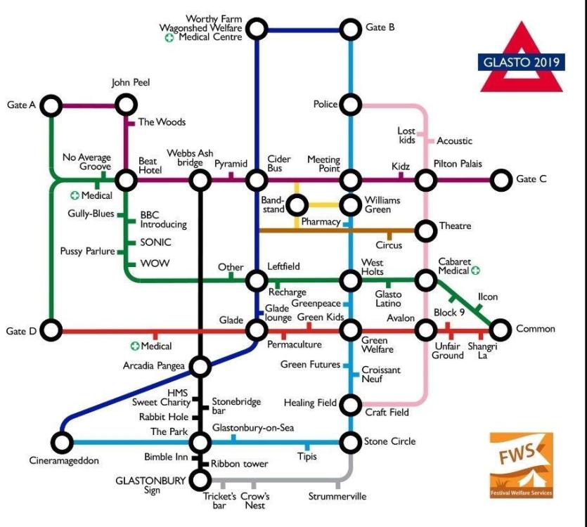
Hey everyone! I reckon I've just about finished updating the Glasto tube-style map for 2019. You guys have given some useful feedback on this the last couple of times and I know a few of you have found it useful so let me know what you think!
This is based on as much as I could glean from a fairly recent General Site Plan and various comments from all over. I've managed to cram in a few more points of interest, hopefully without getting too cramped, reworked Silver Hayes to better reflect the layout, and updated the naughty corner to match the current set up. It aint perfect – wanted to add a few other bits and pieces – but think it's pretty much ready.
Are there any glaring flaws? Obvious omissions? Want to draw a line under it soon so I can get it printed to go outside the Green Welfare tent ?️☕?

-
2
-
36
-
-
1 hour ago, Sawdusty Surfer said:
Many try but always fail to get past our wonderful gatecrew
(BTW, I'm your neighbour, just uphill of you with the woody stuff,)
Mornin' neighbour <tugs on brim> See you in a few weeks. Might try bothering you for your chainsaw at some point if you don't mind? For the firewood.
22 minutes ago, Aragorn said:Cheers dude - I will look out for you
Rotating shifts so couldn't tell you when I'll be on but keep an eye out for the brown stripy jumper answering to Pete.
-
7 hours ago, Aragorn said:
You will probably see me alot as I like nothing more than to sit by the fire at welfare and chill out when my anxiety levels are on the rise which is on and off during the festival, feel safe there
That's cool man. That's why we're there and why we have it burning all night, every night
If you see a tall guy with a beard hoofing logs onto it say Hi and I'll make you a cuppa ☕
-
1
-
-
I work at Green Welfare. That's immediately south of the railway track right at the junction where you exit from the one-way system. I can personally attest that those security guards will not let you through - even when it's pretty quiet. The one-way system is taken very seriously and it's just not worth the hassle they'd catch if they let the odd body slip through.
Related point, we very occasionally get a few punters trying to rush behind Welfare hoping they can cut through our camping area (full of sleepy shift-workers and kids) and through the hedge onto the track. I daresay Croissant Neuf get the same through their staff camping area too. These guys are not popular and that hedge is way pricklier than it looks. This strategy 100% never works.
-
17 hours ago, Bluebeth said:
Amazing, do you mind if I have this printed on a t-shirt?
The more you do the happier I'll be
-
4 hours ago, River said:
Hey, would you mind if I printed it on a canvas for display on my festival picture wall? I love it!
Go crazy. Please use it, share it and have a great festival.
-
13 hours ago, Gnomicide said:
@deadstillstanding, hope you don't mind but I've posted it on Twitter, with a credit and a link to the original post of course. Getting a lot of love on there too.
Are you on Twitter so I can tag you in?
Not at all. Please share it far and wide. I want it to be used. I'm @deadstill on Twitter and Instagram.
Good night from the site!
-
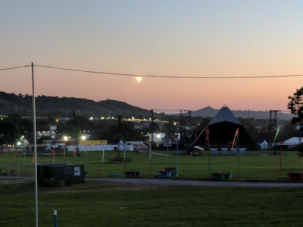
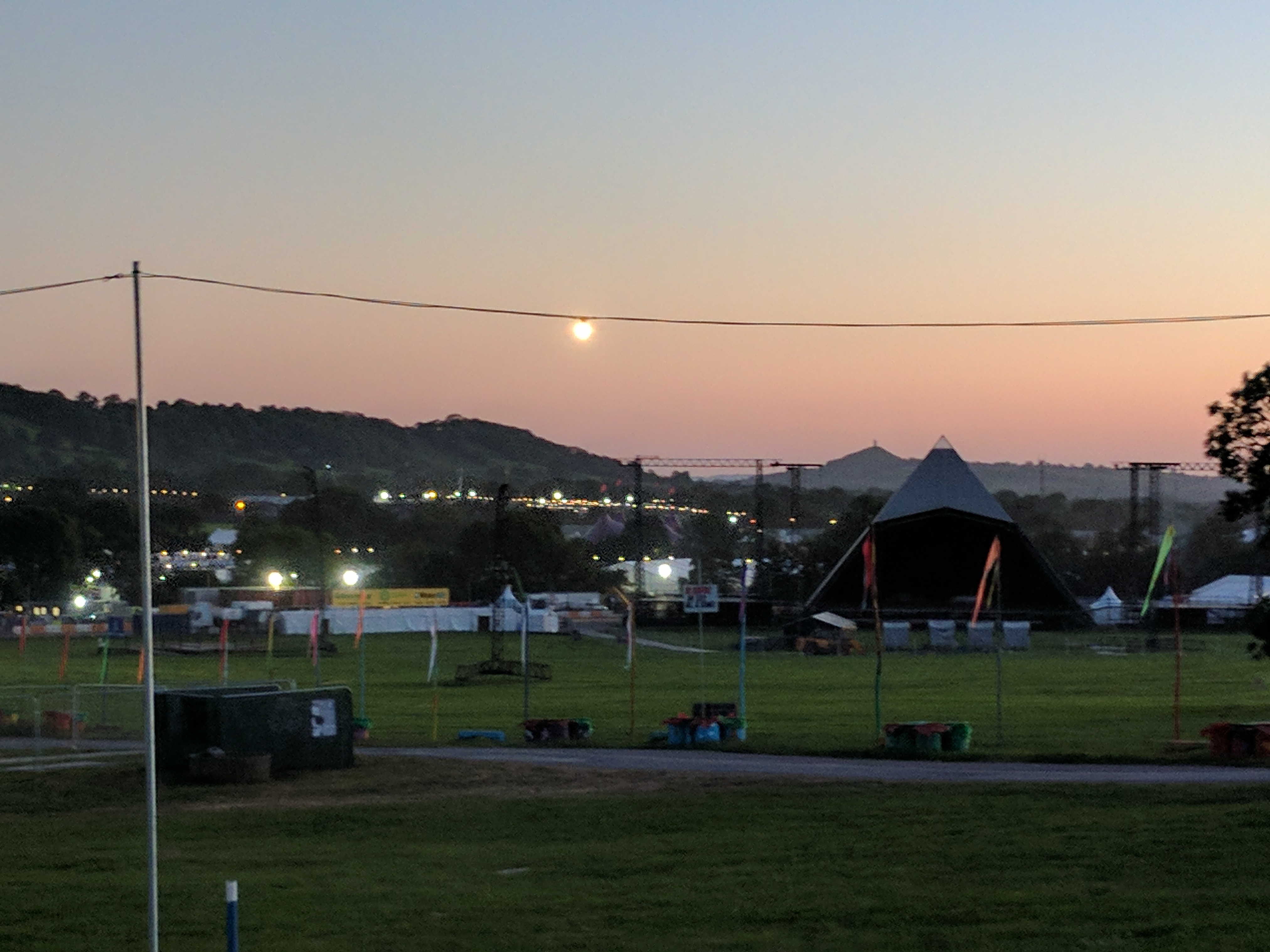
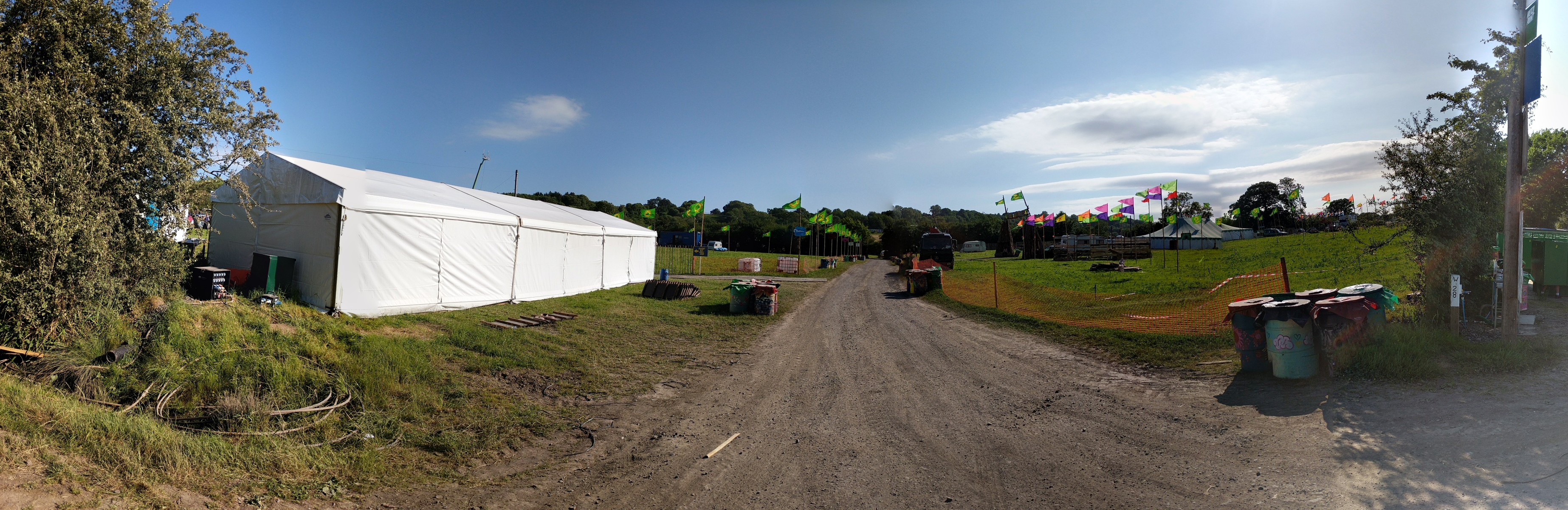
Well it was bloody lovely yesterday and I'm looking forward to an amazing week, even if the weekend goes a bit wobbly.
Pic from about 5pm looking into Greenfields.

-
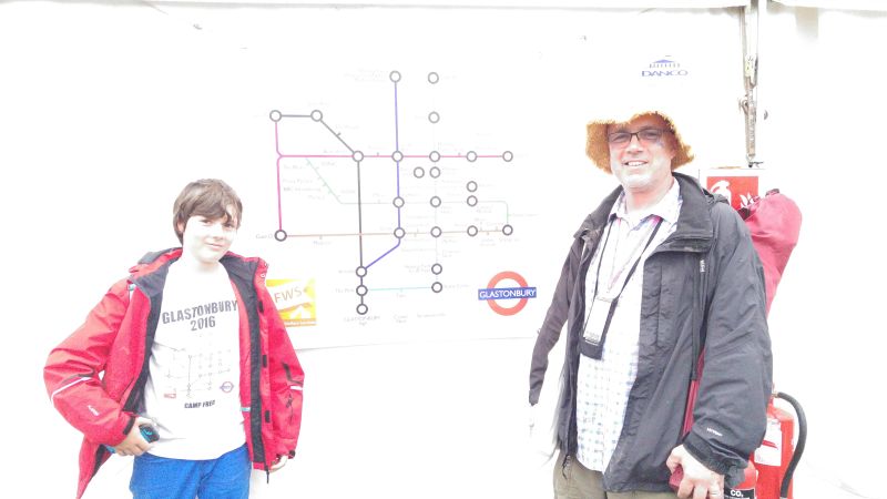
1 hour ago, Neville Street said:
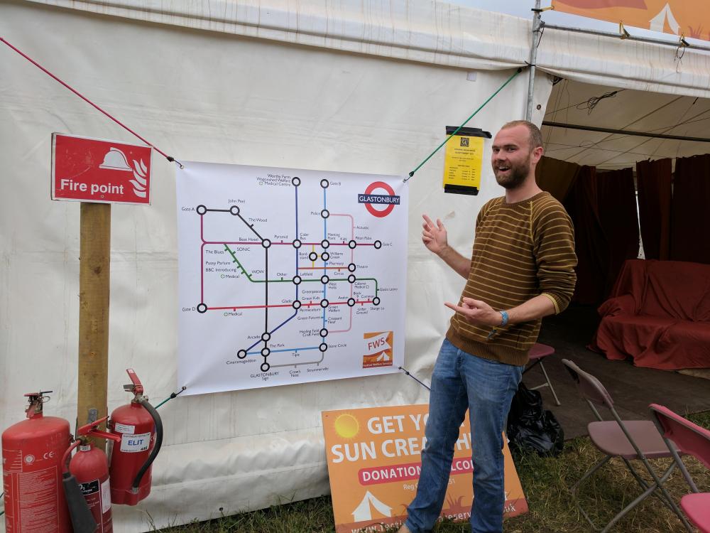
We visited FMS and chatted to Pete on the Sunday, they have a giant map up there on the side of the tent.
It's true! Very chuffed I was too. Not sure Neville Street junior was as convinced...
-
17 minutes ago, paulshane said:
would a slight change like this settle everyone down ?
It definitely might improve Silver Hayes.
The discussion is all good though. There are a few different ways to do this map, I know 'cos I've tried them all. Last year I spent the best part of a week trying to reconcile the tube map logic with the functional reality of being a lost punter wandering around at Glastonbury. I think this strikes the right balance between it being a slavish TFL tribute map, something that makes sense on the ground, and not looking too messy. I'm 100% willing to revise if anyone comes up with any good ideas.
-
19 minutes ago, mjsell said:
I hate to argue, but there is nowhere on a London tube map where a line ends when not at a station like the green line does in your glasto version. If it is followiing the tube map layout style It should either continue running parallel with the purple to Gate A/D or end at The Blues.
As I say, the difference is that on the tube there's a station at every lines' terminal, but station means something different on this map so it wouldn't make sense to put one on in this case. The path through Silver Hayes continues past the Blues until it terminates where it meets the other path.
-
18 minutes ago, mjsell said:
Thats not what happens on the normal tube map. The lines would run parallel to one another until their teminus station.
Like I said, its not important and the creation looks and is fantastic, it was just a tiny sidenote.
I respectfully disagree. Several lines terminate when they meet another line. It's only if a service runs to a shared terminal that the lines continue in parallel. The difference is that on the tube there a station at a terminal, whereas on this map the 'stations' are stages or other points of interest, which don't appear at every junction. I did try putting stations on all the line intersections but it didn't make much sense and looked like I'd just forgotten to label them.
-
40 minutes ago, mjsell said:
Add on question. What would you name each of the lines?
Some are easy - old railway track, muddy lane, etc. But most don't have commonly known names so it wouldn't help.
39 minutes ago, mjsell said:I love this tube map btw, but I do have the tiniest of issues with what happens to the line after/before the Blues?
Not sure I follow..? That route ends when it meets the other. What's missing?
36 minutes ago, paulshane said:brilliant stuff
but should the circles be 'doubles' showing you can change lines ?
disclaimer: i don't live in london, so dont see a tube map very often
Nah. The doubles on the tube map are when there are two sections to a station with an underpass or whatever connecting them. Doesn't really make sense on here. I did try using them for areas like the Pyramid and Other but it just looked a bit dump as didn't really help.


Festival layout/map 2022
in Chat
Posted
Actually, ignore me. The just-released EE map has most of the smaller stages on it. Gonna crib that and call it a day. Will post the result here once ready.