

-
Recently Browsing 0 members
- No registered users viewing this page.
-
Latest Activity
-
 Yeah I had that as Carhenge Also the map has come early May the last 2 years, but most years before that it's been mid-April, so I guessed they'd want to get back to the usual announcement time for it.
 -

By Nice hymer · Posted
The festival has done this in previous years (2019). Lots of people were gaming the system to obtain local tickets (to the point where genuine locals were missing out). GFL sent out emails to request recent proof of address (drivers license, council tax bill, polling card), anyone who couldn't provide their details were correct had their tickets cancelled after 14 days. So it's at least possible... -
By Quadrophobia · Posted
fair point, but then these type of comments ⬇️ suggest to people there is any knowledge at all about the timetable which there isn't. Apart from the headline and some electronic acts placing an act at any time on any stage is a completely wild guess. This board is read by many more people than just those with accounts. -
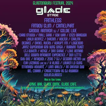
This is what I was hoping would happen re the long term future of nightlife areas. Have the heavy hitters on at areas like the Glade and SH and spread people out across the site. I like SEC but feel like Glade and SH work better as areas to hear big DJs and SEC is more immersive. What’s the point in packing out Shingri La for a DJ set if you can’t do the fun stuff and interact with the actors after dark?
-
 That's exactly what I thought. Difficult to believe I know!
-
-
Latest Festival News
-
Featured Products
-
Hot Topics
-
-
Latest Tourdates


Recommended Posts
Join the conversation
You can post now and register later. If you have an account, sign in now to post with your account.